
THE COMMONS EXPLAINED, #5, Shared Ground
How the Yountville Commons became a practical civic framework that could grow carefully, one completed phase at a time.
By Brendan Kelly and Amie MacPhee
Amie MacPhee is the founder of Cultivate LLC and served as the Town's lead landscape designer on the Yountville Commons project. Brendan Kelly's firm, Kelly + Morgan Architecture, served as the Town's Owner's Design Consultant on the project; that scope is complete.
Summary: The Yountville Commons has become known for the thing people fought over, which was housing. The drawings describe a different project. On the 7.5-acre site, civic buildings occupy about 6 percent of the ground and all of the homes together occupy about 12 percent. Roads and parking, set on permeable paving, take another 17 percent. The remaining 65 percent, nearly five acres, was reserved as open public landscape: a creek walk, meadow, gardens, groves, courtyards and a dog park, open to every Yountville resident and visitor. The plan was also designed to be built in workable increments as financing allowed, with each phase completed as a real piece of the Commons. The pace could adapt. The quality of the civic place at the heart of Yountville was never supposed to be bargained away.
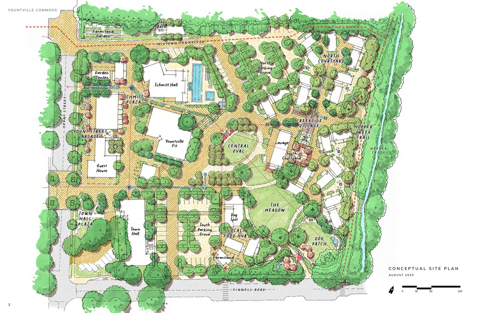
Civic and Residential buildings along Yount Street, housing neighborhoods gathered along Hopper Creek, and nearly five acres of public landscape between them: the Central Oval, the Meadow, parking groves, gardens, and the creek trail. The plan was conceived to be built one completed piece at a time, each phase finished with its own trees, paving, and courtyards.
What the Argument Obscured
After a long public fight, a project tends to be remembered as the thing people fought about most. In Yountville, the Commons became synonymous with housing. Unit counts, building heights, parking, financing, traffic, density, and the proper role of local government consumed almost every other part of the conversation. That is understandable. Housing was the controversial part of the proposal, and controversial things absorb the oxygen around them. Over time, however, the argument produced a distorted picture of what the Town, through its elected Council, had spent more than two years planning. The Commons was never conceived as 7.5 acres of housing with public amenities scattered around the edges. It was conceived as a public place, on publicly owned land, with civic uses, gardens, paths, gathering spaces, and middle-class housing integrated onto the site of the former elementary school.
The proportions make that distinction easier to understand than any adjective can. About 65 percent of the Commons was reserved for open space and landscape: walking paths, gardens, Hopper Creek, play fields, the dog park, courtyards, groves, and other shared outdoor spaces. Another 17 percent was devoted to roads and parking, set on permeable paving. About 6 percent accommodated dedicated civic uses, including Town Hall, Yountville Fit, the Farmstand, Schmitt Hall and related public facilities. Residential buildings occupied only about 12 percent of the site. The part of the Commons that now dominates the political argument stands on roughly one-eighth of the ground. Nearly two-thirds is intended to remain open public landscape, a clear priority by the hundreds of residents who participated in the two-year-long planning process.
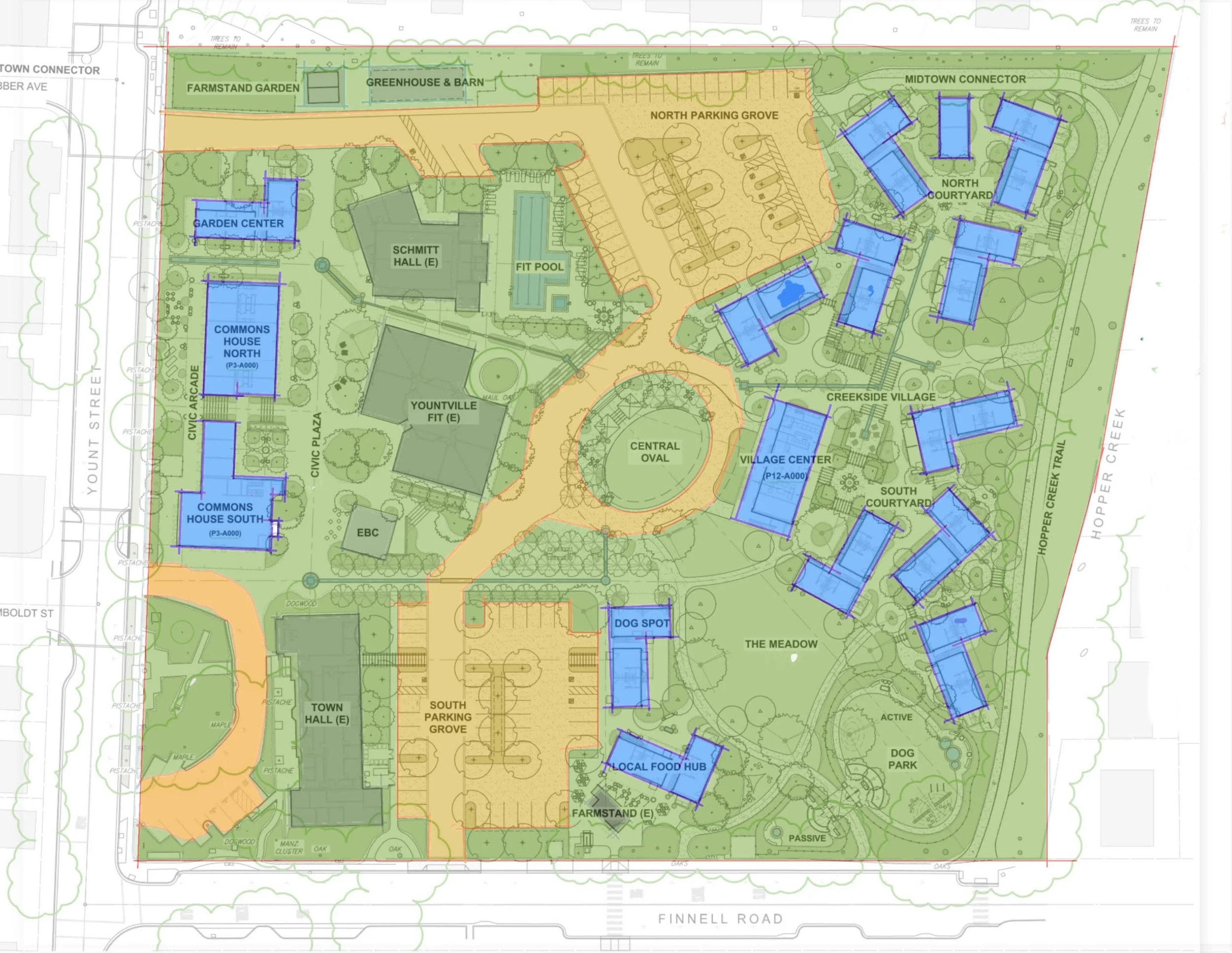
Site overlay showing how the ground is divided. Green is public open space, about 65 percent of the 7.5 acres. Housing, in blue, occupies about 12 percent. The Commons was never meant to be dominated by housing, but the homes are essential to the plan: they give the meadow, courtyards and lanes their edges and their daily life, and they were sized to be built at a pace Yountville sets for itself.
Those numbers are worth revisiting because the argument around housing has lasted long enough to begin replacing the project in public memory. For residents who supported the Commons, the drawings included in this essay are a reminder of what more than two years of public meetings, workshops, revisions and compromises produced. For residents who doubted it, they are an invitation to see the proposal as it was: a workable civic plan designed to be financed and built in increments, with later phases informed by what the Town learned from the first. Looking closely does not require anyone to endorse every decision. It simply allows the project to be judged by the plan itself rather than by campaign material, petitions, or someone else's description.
Before There Was a Housing Fight, There Was a Commons
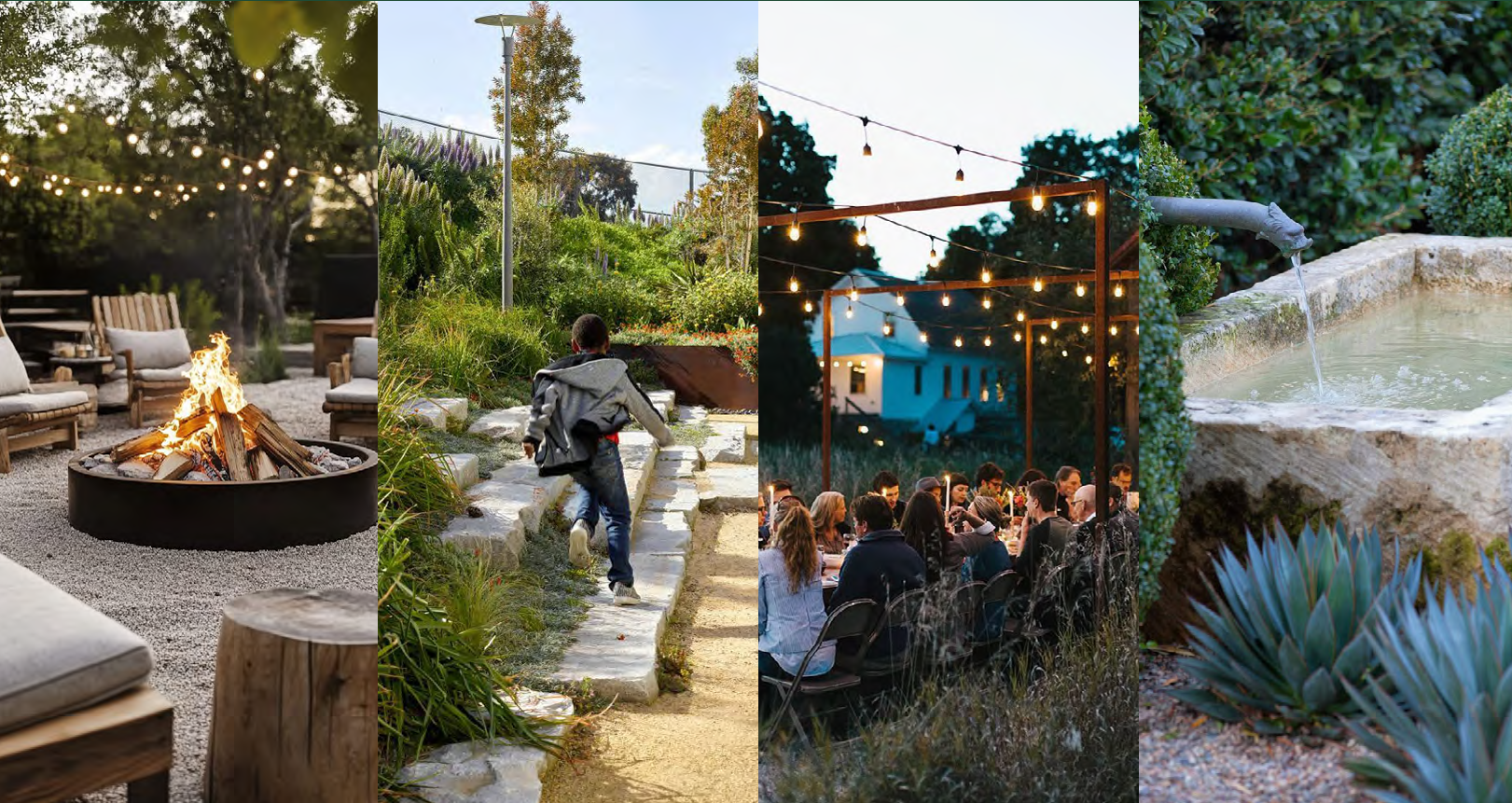
Precedent images from the Landscape Workbook: a fire circle, a planted stone stair, a long table under string lights, a stone basin fed by a spout. These are the kinds of outdoor rooms the Commons was meant to hold, closer to the courtyards of Yountville's inns than to the mown lawn and picnic shelter of a conventional town park. The difference is in the materials, the shade and the scale, and in being open to anyone who visits.
The Town purchased the former elementary school because 7.5 centrally located acres of public land in Yountville represented something exceedingly rare: the opportunity to create a large civic asset in the middle of an already built town. The earliest physical changes reflected that purpose. The fences came down, and the grounds opened for public use. Yountville Fit moved into the old library, the old Little League snack shack became the Farmstand, the new dog park established a regular daily use, and Schmitt Hall rejoined the civic inventory for public events, including popular Kids Camps during summer and school holidays. Residents who had spent decades passing an enclosed institutional campus began crossing it, walking through it and using it.
The name Commons was therefore more than branding. It expressed the premise of the undertaking. This was no longer simply the former elementary school, nor land held for one narrowly defined municipal function. It was meant to become shared ground at the center of Yountville, where civic life, recreation, landscape, movement and residential uses could coexist rather than being sorted into separate compounds. Housing entered the conversation because Yountville faced an increasingly obvious problem: many middle-class people who work, manage businesses, care for residents, staff the Town, raise families and keep the community functioning could no longer afford to live here.
The proposal did not answer that problem by consuming the Commons with housing. It attempted something more difficult. It asked whether homes could be introduced without surrendering the qualities residents most feared losing: openness, trees, gardens, walkability, small buildings, views through the site, informal gathering places and a landscape that felt recognizably like Yountville. Many objections were ultimately physical. People feared three-story buildings, exposed parking lots, and a project that would read as dense development rather than an extension of town. The Landscape Workbook prepared by the design team addressed precisely that concern and the images of that public document are part of this essay.
The Housing Was Inside the Commons
None of this means the housing was incidental. Middle-class housing was an important part of the plan, and one reason the Commons became politically difficult was that the Town chose to finally address a problem that had grown for decades. Yountville has become increasingly impossible for ordinary working and middle-income households to enter, and increasingly hard for younger families to remain in. Adding deed-restricted homes on public land that could not be converted to vacation rentals or second homes was an intentional response to that condition. Measure S passed in Yountville in 2018 by 74% of the vote of the town to fund exactly this kind of effort.
But physical importance and political controversy are not the same as physical dominance. The amount of land dedicated to this important new housing component occupied only about 12 percent of the site, distributed within a larger system of paths, gardens, civic uses, parking groves, creek landscape, and public open space. The Commons is a public place that includes homes, not a housing development that included some leftover open space.
Recovering that distinction does not require anyone to change positions. A resident can still object to the number of homes, height of buildings, financing, ownership, or the pace of progress. Those are legitimate subjects for argument. The more useful first step is to stand over the Town's site model and see the proposal as a whole: the limited building footprints, the continuous public landscape, and the sequence in which complete phases could be built. The model was made so the plan could be seen rather than imagined.
The Landscape Comes First
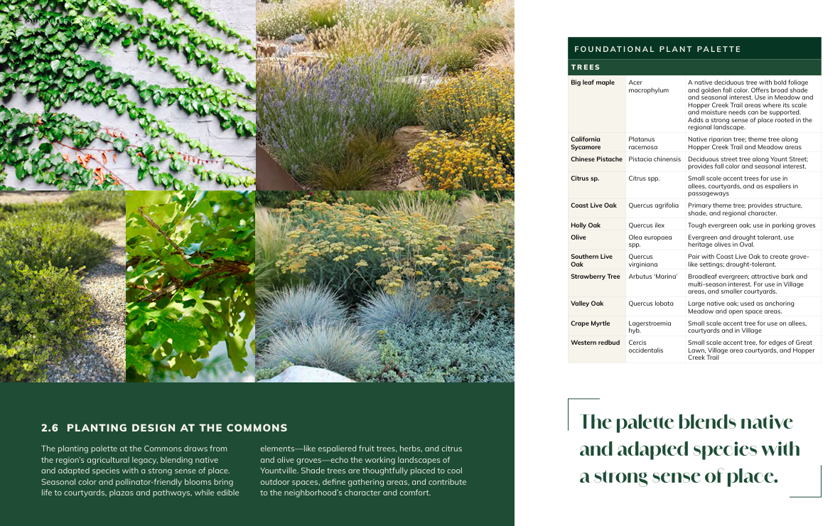
A page from the Landscape Workbook's planting section. The tree palette is native and drought-tolerant: coast live oak and valley oak as the structural trees, California sycamore along Hopper Creek and the Meadow, holly oak in the parking groves, with citrus, olive, redbud and crape myrtle as small accents in the courtyards and allees. Each species is assigned to a specific part of the site, so the planting is tied to the uses around it rather than spread evenly as decoration.
The workbook's premise appears near the beginning: the plan is about extending Yountville's small-town heart by threading together a sequence of meaningful places that feel as though they have always belonged. The workbook does not begin with buildings and ask what landscaping can fit in the spaces left over. It begins with the landscape and uses it to determine where buildings, streets, parking, and civic uses belong.
That difference is easy to underestimate. On many development projects, landscape architecture arrives after building footprints, parking, fire access, utilities, and economics have narrowed the choices. What remains becomes the landscape. It may look attractive in a rendering, but it has little authority over the plan because the decisions that matter were made before it arrived.
The Commons was organized in the opposite direction. The public realm was drawn as a continuous system of outdoor rooms, paths, groves, gardens, and civic spaces, and the buildings were arranged to reinforce it. The landscape would determine how a person moved through the site, where shade fell, where neighbors might stop, how the creek was protected and experienced, and how a three-story building could sit within a much larger setting rather than dominate it. The distinction between 65 percent landscape and 12 percent residential footprint is therefore not merely statistical. It describes the design philosophy itself.
The Three Fabrics
The Landscape Workbook organizes the Commons into three interdependent layers, or fabrics: green, gray and built. The order is deliberate.
The green fabric comes first, and on this site it carries a second job. For decades the school grounds were mostly asphalt and lawn, an institutional surface with many heritage trees only at the margins, and the green fabric is the plan's answer to that condition. More than 400 new native trees are proposed across the 7.5 acres. Hopper Creek, long treated as the edge of the property, remains an integral part of a walking network of the site. Open space is not a leftover lawn or one park in a corner, but a sequence of places distributed across the site. The Meadow and the Oval create larger communal spaces, while courtyards and paseos provide smaller ones. Orchard groves, edible gardens, the Farmstand Garden, dog parks, and shaded pedestrian connections give each part of the site an identity and a reason to be used. Together they form a network of outdoor rooms, so walking through the Commons would feel like moving through a small district rather than crossing a housing development. That is how most historic towns came to fit their natural settings, slowly and by accumulation. Here the accumulation begins by putting the ground back in working order.
The gray fabric describes movement: streets, lanes, parking, service areas, and paved connections. Parking sits beneath orchard-style tree canopies rather than in broad asphalt fields. Permeable paving softens surfaces and keeps stormwater within the visible environment. Low walls, planting, trellises, and changes in paving screen service functions without creating fortified backyard zones. Narrow water runnels were proposed through selected courtyards and walks, recalling Hopper Creek through sound and cooling. Even the parts devoted to cars were made to participate in the landscape rather than interrupt it.
Only after those systems are established does the workbook describe the built fabric. Buildings define outdoor spaces, reinforce street edges and shape transitions between public, semi-public and private areas. A porch can address a courtyard rather than a parking lot. A lane can widen into a plaza. A civic building can share a landscaped space with homes. Along Yount Street, the Arcade and Schmitt Plaza were conceived as the Commons' public face, stitching civic, residential and neighborhood-serving uses together through shade, planting and pedestrian movement. The buildings were meant to support the experience of the place as a whole.
What Three Stories Are Supposed to Feel Like
Some opposition focused, understandably, on height. Yountville is a low-rise town, and three-story buildings suggested to some residents large apartment blocks rising above open parking lots. The Landscape Workbook allows that fear to be tested against the plan rather than against an imagined version of it.
The buildings were deliberately small in footprint and distributed rather than consolidated into one or two large structures. Tree canopy mediated scale. Courtyards, groves, porches and planted edges created distance and layers between pedestrians and building faces. Streets and lanes were narrow and landscaped, and parking was broken into shaded areas. A three-story building remains a three-story building, but the design placed it within a mature spatial framework so height would be experienced together with shade, trees, open space and the horizontal continuity of the landscape.
That approach is familiar in Yountville, because some of the town's most carefully designed places already use it.
What Yountville's Hospitality Landscapes Teach
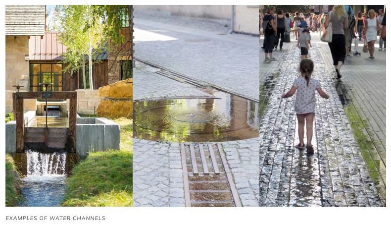
Precedent images for the water runnels proposed through selected courtyards and walks, recalling Hopper Creek through sound and cooling. Moving water is already familiar in Yountville, in the fountains and channels of the town's hotels and inns, where it is part of what a guest pays for. The Commons puts the same element on public ground, behind no gate and requiring no room key. The land belongs to everyone.
Visitors rarely describe Yountville by listing the square footage of its hotels. They remember the spaces between the buildings: trees arching over paths, stone walls softened by planting, courtyards discovered through narrow openings, fountains heard before they are seen, garden rooms, gravel walks, trellises and vines. Those qualities did not happen accidentally. The town's best hospitality properties understand that landscape is part of the product they sell, and they invest accordingly.
At a good hotel or inn, landscape is not what remains after the building budget is finished. It is part of the reason someone books the room. Trees are allowed to mature, courtyards receive real materials, planting is layered rather than residual, and water, lighting, furniture, and paving contribute to the experience. The spaces between buildings receive the same seriousness as the buildings because hospitality understands something civic development often forgets: people experience places at walking speed.
The Commons borrowed from that tradition with one important reversal. The intended beneficiary was not reserved only for the paying hotel guest. The Commons landscape was designed on public land for residents first, while remaining open to visitors, neighbors, and anyone moving through town. The creek walk requires no room key, and the gardens, meadow, dog park, Farmstand, and shaded paths sit behind no gate. The Commons applied Yountville's familiar seriousness about private hospitality landscapes to ground that belonged to the public and for it to be protected in perpetuity.
A Working Landscape, Not a Decorative One
The planting strategy reached backward into the agricultural history of the valley. Orchard groves, citrus allees, edible gardens and fruit espaliers were incorporated as living parts of the site, not historical props. The Farmstand Garden was meant to remain productive. Fruit trees could provide shade and food at once, and trellises could mark thresholds while supporting vines. Agriculture would remain visible within daily civic life rather than serving only as scenery beyond town.
The detail matters. A project can be called landscaped while containing little more than lawn, foundation shrubs and young street trees at required intervals. The Commons imagined distinct plant communities tied to the uses around them. Hopper Creek was not the Farmstand, a parking grove was not the Meadow, and a residential courtyard had a different degree of enclosure from Schmitt Plaza. Those differences created variety within one coherent place. The ambition was not grandeur, but familiarity, texture, and accumulated detail: the qualities that allow a new place to become part of a town without feeling as though it arrived all at once.
Phasing Without Compromise
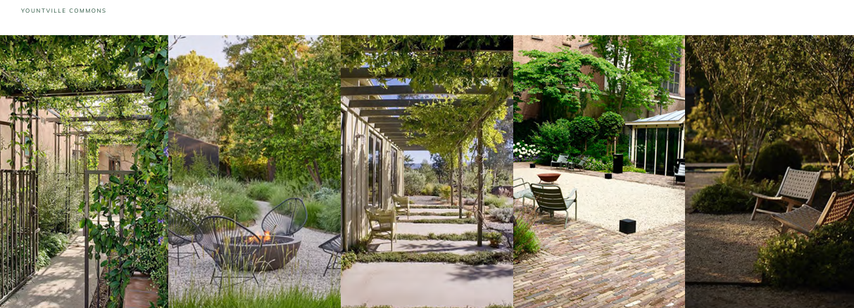
Precedent images for the courtyards and covered walks at the Commons: vine-covered trellises, gravel and brick paving, fire bowls, chairs set under young trees. On most projects these are the first things cut when the budget tightens. At the Commons the landscape was drawn first and the buildings placed to serve it, so each phase was to be finished with its own shade and outdoor rooms. Yountville's promise to residents and visitors is shaded streets and shared outdoor places, and that promise is what the plan was built to keep.
Landscape is usually the most vulnerable part of a project when budgets tighten. Buildings must stand, units must meet code, fire access must work, and mechanical systems cannot be omitted. The pieces most easily called optional are the mature trees, better paving, generous planting, trellises, furniture, and courtyards that made the drawings appealing. A deeply shaded grove can become a handful of saplings if the landscape budget is treated as the contingency account.
The Commons tried to prevent that by making landscape organizational rather than decorative. If the green fabric determines where buildings go, it is harder to remove later without unraveling the plan. Outdoor rooms are no longer filler between structures. They are the reason the structures occupy those positions.
The proposed phasing reinforced the same discipline. Housing was divided among smaller buildings that could be financed and constructed incrementally. Each phase could deliver its own finished landscape, paving, courtyard, and public space instead of postponing those elements until the end. The Town could see what an increment actually cost, learn from it, and adapt later increments as financing and experience allowed. That flexibility was practical, not an invitation to unravel the framework or dilute its standards. If the public landscape was a central promise of the Commons, each piece had to be completed properly, even if that meant building more slowly.
Public Ground Has a Higher Obligation
Ordinary landscaping would not have been enough because the grounds were not intended as private amenities for a housing development. A conventional apartment courtyard can belong primarily to the tenants whose doors face it, and that is appropriate for many private projects. It was not the Commons.
The creek walk, Meadow, Oval, gardens, lanes, Farmstand and groves were intended to belong to Yountville's daily life, serving people in the new homes and the much larger population of visitors that did not live here. A resident could walk a dog without living at the Commons, a visitor could cross from one side of town to the other, and a civic event could spill outside beneath the trees. That public character raises rather than lowers the standard. A civic landscape occupying most of one of the Town's most important properties must earn its place in everyday life.
A Gathering Place, Not Just a Development
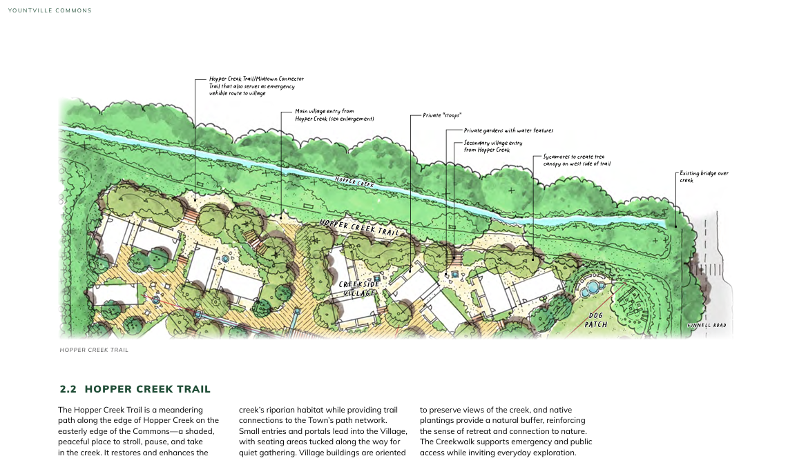
Hopper Creek Trail, from the Landscape Workbook. The path runs the length of the site's eastern edge between the creek and Creekside Village, under new oaks and sycamores, with seating tucked along the way and small entries leading into the village. The creek's riparian habitat is restored rather than fenced off, and the trail connects to the Town's existing path network and the bridge at Finnell Road. A place many residents already walk was to be protected and made better, and it was drawn as one of the main ways into the Commons for everyone.
Look closely at the images, and what remains is not primarily a unit count. It is a creek walk, meadow, parking groves, dog park, trellises, courtyards, water channels, edible gardens, and paths offering several ways through the site. These are not amenities sprinkled around development. They are the structure of the proposal, covering nearly five of the site's 7.5 acres.
The Commons imagines shared places woven into ordinary life: a morning walk beside Hopper Creek, a picnic on the lawn, a conversation outside Yountville Fit, children crossing on bikes, a book club or knitting group near the Farmstand, a shaded route home, an evening gathering beneath trees that grow more valuable as they mature. The buildings matter within that composition, including the homes, because they give shape and activity to the spaces between them.
What Two Years Produced
The Commons that emerged from more than two years of public work was not a finished monument awaiting construction in one enormous act. It was a workable civic framework designed to grow over time. Financing, construction methods and the precise program of later increments could respond to what the Town learned from the first phase. That is a strength of the plan, not a sign that its central commitments were provisional. The open public landscape, civic uses, limited housing footprint and careful relationship among them gave every phase a common direction.
The former school site remains one of the most consequential pieces of public land Yountville is likely ever to control. The plan gives the Town a sound place to begin: nearly five acres of public landscape, civic uses at the center, housing within a limited footprint, parking treated as a landscape problem, and a sequence of increments that could be financed and completed without pretending the whole site had to appear at once. What was never supposed to be bargained away was the level of quality: the trees, gardens, paving, courtyards, buildings and careful relationships that would make each increment feel complete and worthy of public land and civic uses.
Residents do not need to agree on every unit or every future appropriation to recognize the value of that achievement. They need only see the plan for what it is: a public place that can grow deliberately, one well-made piece at a time. Yountville has the land, the framework, and the capacity to build it well.
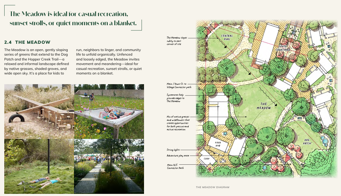
The Meadow, from the Landscape Workbook: an open, gently sloping green of native grasses and wildflowers, edged by sycamores and running from the Central Oval to the Dog Patch and Hopper Creek Trail, unfenced and open to anyone who walks in. It is one of several outdoor spaces drawn before any housing was placed on the site. The phasing was designed the same way, with each increment delivering a finished piece of the public landscape for every resident of Yountville, wherever in town they live.
