
The Shape of Belonging
Why the Commons was designed as a public place, not just a housing project.
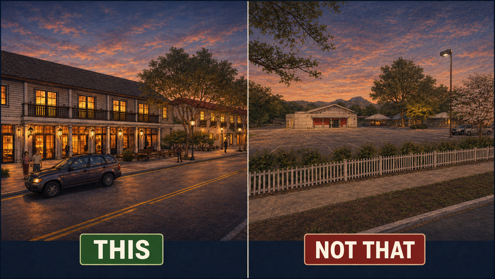
The difference is not style. It is civic form. One side shows buildings creating a public place; the other shows a public site still dominated by asphalt, distance, and leftover space. The Commons proposal was an attempt to make the former school site feel like part of Yountville again.
“Form-based design” is an unfortunate phrase for a very old civic idea. It sounds like something from a planning seminar, a zoning code, or a consultant’s report. It sounds technical before it sounds human. But the idea itself is not technical at all. It is the difference between asking, “How many units can fit here?” and asking, “What kind of place are we making?”
The fence came down first. Before the studies, before the meetings, before anyone argued about how many homes the site could hold, the Town pulled the chain-link off the perimeter of the old elementary school and let people walk across the grounds again. By that summer the cafeteria had become Don and Sally Schmitt Hall, the library had become Yountville Fit, the old Little League snack shack had become a farmstand open six days a week, and a corner of the playfield had become the town's first dog park. None of that required a master plan. It required only the decision to treat the ground as a shared public space again. That decision came before everything else, and it is the right place to begin, because it explains what the Commons was always trying to be and still can be.
The design method behind the project goes by an unfortunate name. "Form-based design" sounds like something from a planning seminar, technical before it is human. The idea underneath it is neither. It is the difference between asking how many units a piece of land can hold and asking what kind of place the land should become. The first question produces a number. The second produces a part of a working town. At the former school site, in the center of Yountville, the second question was the only one worth asking.
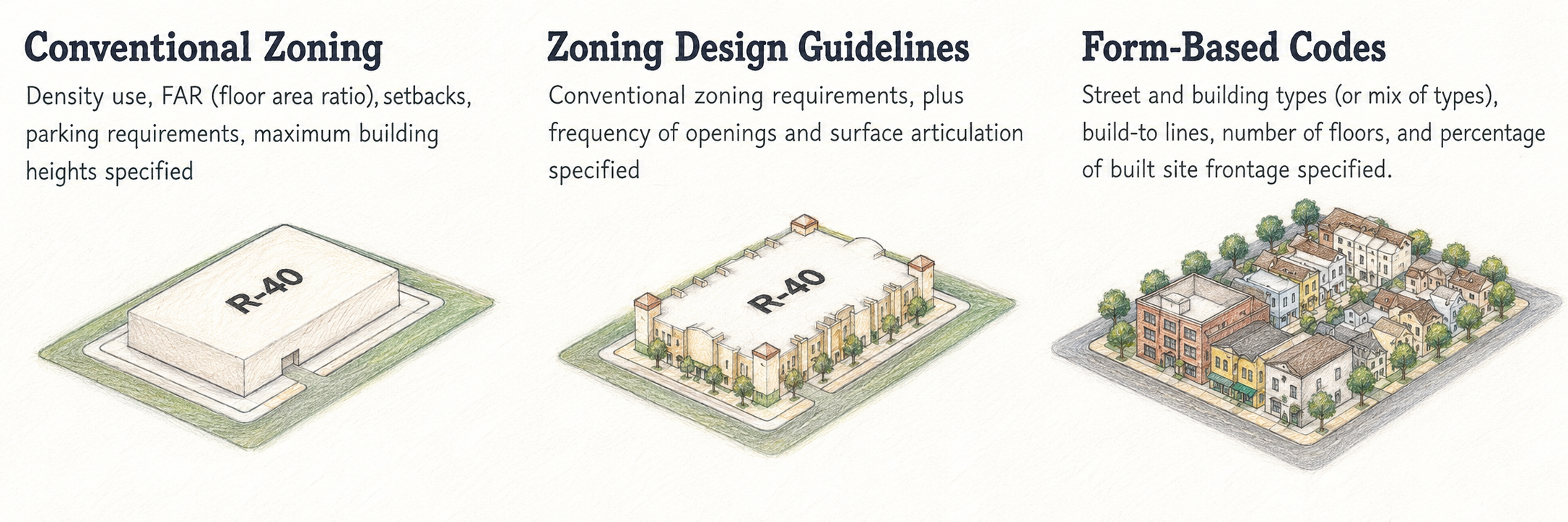
From zoning categories to civic form. Conventional zoning can tell a town how much may be built, how tall it may be, and how much parking is required, but it does not necessarily make a place. The Commons design asked a different question: how should housing, civic buildings, gardens, fields, walks, parking, and shared outdoor spaces fit together so the former school site could become a walkable part of Yountville accessible to all residents?
Housing mattered, and still does. A town where most of the people who cook, clean, pour wine, and care for its residents cannot afford to live near their work has a civic problem, not merely a real estate one. Yountville has watched its school close after more than 125 years, its year-round population age, and a large share of its houses go dark for most of the year as second homes. The temptation, facing all of that, is to set subsidized units on a leftover piece of public land and call the matter settled. The school site was too important for that. It was one of the last large pieces of ground in the middle of town that belonged to everyone, and it carried the public memory of generations who had crossed its paths as children.
Form-based design begins with the public experience and works inward. It asks what a building contributes to the space around it before settling what the building looks like, where people will walk before how many units will fit, and where the trees and open ground belong before where the cars will sit. In a conventional development the order runs the other way. Buildings and parking take their share first, and the public realm is assembled from what remains. Paths become circulation, trees become landscaping, and open space becomes a buffer between things. The Commons reversed that sequence and let the public life of the site set the terms.
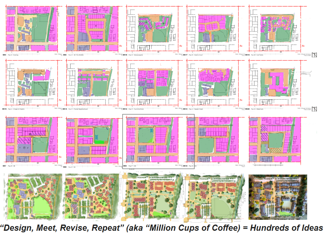
Design, meet, revise, repeat. These studies show the Commons framework took shape over time, as housing, civic uses, gardens, fields, walks, parking, and shared outdoor spaces were tested together as one public place.
During the public process the Town returned again and again to a single sheet of small site studies, each one another attempt to fit buildings, walks, fields, gardens, parking, and civic rooms together on public land. The point of the sheet was not that every study was good. The point was that the plan was argued into being in public view, one revision at a time.
The public debate tended to reduce the Commons to its housing, but housing was only one part of the framework the Council eventually approved. The larger share of the site was given to the things between the buildings: walking routes, open fields, gardens, recreation, shaded parking, civic rooms, and shared ground meant for residents from across town. That arrangement did not arrive whole. It came out of repeated meetings and revisions, with resident comment shaping the plan rather than reacting to it from outside.
One early choice tells the rest of the story. The plan imagined a series of shared outdoor spaces rather than a collection of private backyards. A backyard makes sense in a subdivision, where each household holds its own ground behind its own fence. On one of the most important public sites in town, that same fence would have carved the common ground into small private claims and turned the buildings inward, away from each other. A shared courtyard, lawn, garden, or shaded walk does the opposite. It lets private and public life sit near one another without collapsing into one another. The aim was never to erase privacy. People who live at the Commons will still need quiet, thresholds, and separation from public activity. The question the design kept asking was whether the land could work harder for the whole town than a row of fences would allow.
The placement of cars followed the same logic. In many projects parking quietly becomes the real master plan. The buildings arrange themselves around it, the paths bend to accommodate it, and the first thing anyone sees on arrival is asphalt. Once that happens the character of the place is settled, and no amount of later planting will undo it. The Commons treated cars as necessary but secondary. People still drive, workers still commute, and visitors still arrive at the curb, so the parking had to be real. It was gathered into groves of oaks and broken up so that it would not read as a single field of pavement. The intent was not to pretend the cars away. It was to keep them from owning the room, which is an old principle of town-making and not a new one.
The buildings carried a related discipline. Public argument about a project like this tends to fix on height, density, and whether a given building looks too large standing by itself. Towns, though, are not made of buildings standing by themselves. They are made of the relationships between them. A plain building can be a good one if it shades a walk, frames a courtyard, and gives a clear front to a public space. A dramatic building can be a poor one if it turns its back on the street and leaves dead ground behind it. Most of the buildings at the Commons were meant to be calm enough to support public life rather than compete with it. The few deliberate exceptions, a community hall, a civic porch, a place for children, a corner where people naturally stop, were meant to carry the public weight, and the background buildings give those places their shape. Good civic design works less like a beauty contest among buildings and more like choreography.
This is the part of the tradition that does not require a planning degree to judge. Christopher Alexander wrote about the patterns people recognize without being taught them: a sunny courtyard, a protected edge, a walk that leads somewhere worth reaching. Jane Jacobs wrote about the ordinary overlap of a working street, where different people use the same ground at different hours for different reasons. Leon Krier drew the line between the everyday fabric of a town and its few civic landmarks. Elizabeth Plater-Zyberk and Stefanos Polyzoides spent careers writing those lessons into codes other towns could use. The Commons borrowed from all of it, but the purpose was local. The question was what the old school grounds should become now that they belonged to everyone.
Two answers were available, and both fell short. The site could have been kept as mostly open land, lightly improved and heavily remembered. That answer has real emotional pull, because the ground does hold memory and memory is worth something. But a closed school is not a civic strategy, and a shrinking year-round population is not a preservation plan. The other answer was to treat the site as a housing machine and measure it by output. That answer at least faced the need honestly, but it would have spent one of the town's last great civic sites on a unit count. The Commons looked for the path between them. It was not housing instead of public space, and it was not public space with housing tucked into the corners. It was housing used as one part of a larger public place.
That distinction matters most for the people the town says it wants to keep. A young cook, a new teacher, a hospitality worker, a caregiver, a town employee, a son or daughter raised in the valley, can work in Yountville every day and still have no plausible way to begin a life here. A first foothold is more than a lease. A small apartment beside a community garden is not the same as a small apartment behind a parking lot, and a studio on a public walk is not the same as one hidden in a private enclave. The rent on paper may be identical. The life the home opens onto is not.
Holding those two things together, private dwelling and public welcome, was the hardest part of the assignment. A private apartment complex can attend mostly to its tenants. A public park can attend mostly to its visitors. The Commons had to do both at once, which is why its thresholds were drawn with such care. The depth of a porch, the placement of a path, the way a window faces a courtyard, the distance between a farmstand and a front door: these are the means by which a place tells people where they are welcome to gather and where they should leave others their privacy. They are not finishing details. They are the substance of the design.
None of this can be read off a unit count. A density figure will not tell you whether a child can cross the site safely, and a parking ratio will not tell you whether the cars dominate the view.
The physical arrangement is the civic argument.
What the Commons proposed was not a subdivision, not an apartment complex, and not a park with buildings scattered through it. It proposed a piece of town, with the range of uses a piece of town carries: places to move through and places to stay, public faces and private thresholds, a rhythm that changes from morning to evening and lets different generations occupy the same ground without living the same life.
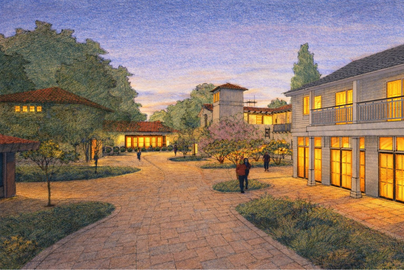
Civic life as the center of the plan. In this Commons study, the existing Town Hall anchors an interior plaza framed by housing, trees, walks, and public rooms. The design shows the purpose of form-based planning: not separating civic life from daily life, but arranging buildings and open spaces so residents are naturally drawn into the shared public life of the town.
Yountville's difficulty was never only a matter of numbers. It was cultural and civic. The population is older than it was, many houses stand empty for most of the year, and the vast majority of the daily workforce is present in the town without belonging to its residential life. The Commons set out to answer that condition in physical form, on public ground, by making a place rather than counting units. Whether it is built in the end, and at what pace, is a separate question the town will decide through its own process. The design itself was an argument about what the old school site should be. It held that the public world is not what remains after the private one is finished, that buildings owe something to the ground around them, that parking should serve a place instead of defining it, and that housing can belong to civic life rather than stand apart from it. Stripped of its jargon, that is all form-based design has ever meant. The fence came down, and the work was deciding what to put in its place.
☾
Brendan Kelly
Yountville · June 14, 2026
Paul Brendan Kelly served as Owner's Design Consultant on the Yountville Commons for two years. That work is complete. He writes here as a private citizen.